What even is El Niño?
El Niño is one half of the ENSO (El Niño-Southern Oscillation) climate phenomenon, along with La Niña. I've heard less about La Niña in my everyday life, so I didn't realize they are two phenomena on the opposite side of a continuum and can't be discussed without each other. They occur in the tropical Pacific waters, but have an impact on weather across the globe. When the ocean is in a neutral state, there are trade winds that blow towards Asia along the equator which sends the warm water on top of the ocean east. Cold water from the depths of the ocean rises up to replace that water, and the cycle continues. In an El Niño event, these trade winds slow or die out, and the warm water stays in the pacific and stops the cold water from circulating. This warming of the ocean causes the Pacific jet stream to move farther south, causing wetter conditions in the southern U.S. and gulf coast. La Niña is the exact opposite, when the trade winds are significantly stronger than usual. There is more upwelling of cold water, and the jet stream is pushed farther north.
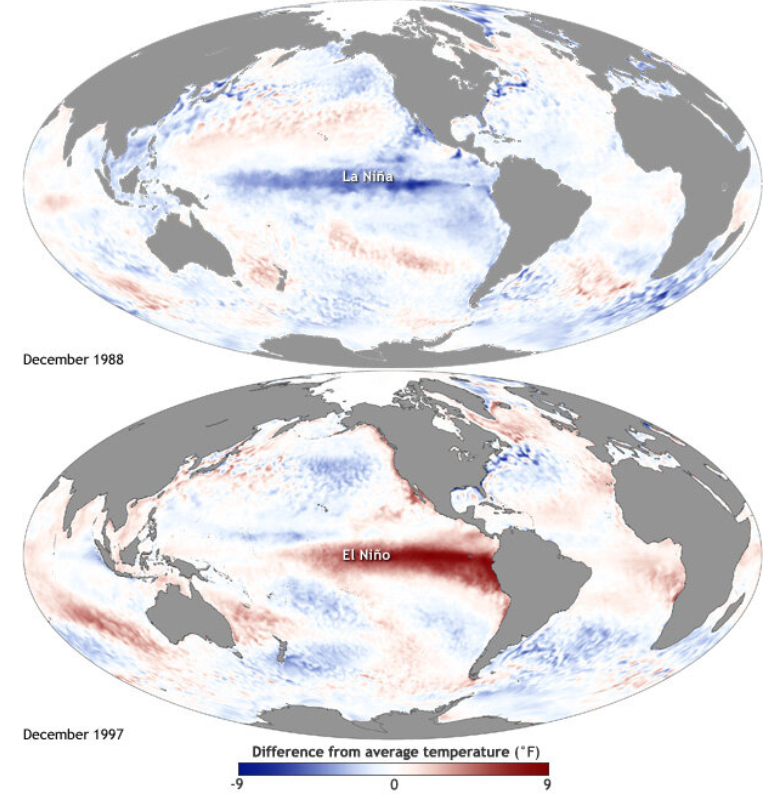
How do we measure ENSO events?
The Climate Prediction Center has a new (this year) measurement called the Relative Oceanic Niño Index that they use to monitor ENSO. It compares the temperature of that specific 2.4 million square mile region (called the Niño 3.4) of the Pacific most affected by ENSO variations to the temperature of the tropics in the rest of the world. The old measure compared the temperature in that region to itself over a 30 year average. The switch to RONI was made because the strength of the effects is based more on the relative warmth or coolness of the Pacific to the rest of the global tropics. This also removes the noise of the oceans warming year over year due to climate change, as it compares the Niño 3.4 region to the rest of the ocean in the current year. In order for an ENSO event to be declared, the temperature must deviate from the average by ±0.5°C for a period of 5 overlapping 3 month periods (which feels like a complicated way to say 7 months I think?)
Other impacts of El Niño
The fresh cold water that is pulled up from the deep also has significantly more nutrients in it so when there is less upwelling, it can impact the marine community. There is less food and thus, less plankton for feeding. This can cause significant migration north and south for marine life, as they follow the cold water.
Another effect of the warmer ocean is higher surface levels (since the warm water expands). The surface height is a key indicator of the temperature. This extra warm water and high surface levels causes a phenomenon called a Kelvin wave. Because the east-west trade winds have slowed, this allows the warmer water with higher surface levels to travel east across the Pacific until it hits the Americas. These are not waves that will crash against the beach, but more like large “planetary” sheets of water that move slowly. They can raise the sea level on the coasts for months as they slowly travel west and then north.
El Niño 2026
The 2026 El Niño is on pace to be the strongest El Niño ever recorded. The criteria to be a “very strong” (the highest official level) is a RONI deviation of +2°C. The strongest event on record is the 2015-2016 El Niño which peaked at +2.75°C. According to the World Meteorological Organization (WMO, the United Nations climate agency and official designator of ENSO events), the 3.4 Niño index hit +2°C in July. Generally El Niño events don’t peak until November, and this one is being forecasted to peak at +4°C. Daily readings have already exceeded +3°C, but haven’t been there long enough to become an official reading.
Clearly, we are moving into uncharted territory with the 2026-2027 event. Below is a general guideline for how the El Niño events affect the planetary weather.
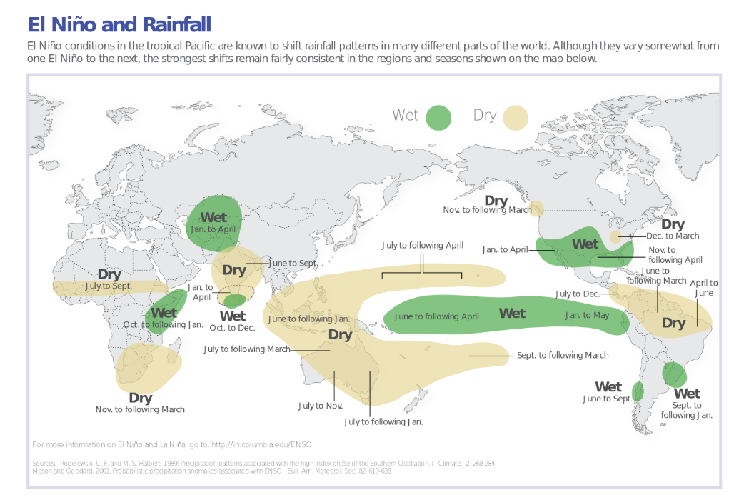
The fact that this could be the strongest El Niño on record doesn’t necessarily mean that these areas are guaranteed to have larger disruptions than normal, but the probability for irregularities is higher. The weather patterns in the Atlantic have already been disrupted, as this is the deepest into a hurricane season ever on record to not have a single hurricane.
I don’t really have much to say about this. Obviously it’s pretty depressing. It has been hard to even research and write about this topic as everything I’m reading is historically bad. And all of these temperature readings are in addition to already record high ocean temperatures. Luckily El Niño effects have been studied for a long time, and the world is already preparing for potentially catastrophic climate events. California is bracing for kelvin waves that could raise sea levels by up to a foot. Australia is bracing for wildfires and drought. In Southern Asia, monsoon rainfall is down up to 50% in areas. I know I’m trying to force myself to pay attention to the world around me, but pulling back the protection of ignorance is brutal.